Stoney Creek to Saranac Village
Another solid day although I’m pretty beat at the end here.
The Stoney Brook section requires paddling up stream away from the Raquette River. The name Stoney Brook is a huge misnomer, I didn’t see a single stone, just winding marshy river. It was more work than I wanted for the start to my morning (so sections the current was strong enough to slow me to under 1 mph). But eventually I got to the Stoney Brook Ponds which had houses on it to my surprise.
As I neared the end of the pond someone let out a loud whoop on the right bank. I looked and saw my quarry, the NatGeo gang. I don’t know if the whoop was intended to get my attention or someone was just loving life but in any case I paddled over.
They were just packing up and getting ready but I talked to one woman who I take it is the guide of the group as she is obviously experienced in the area. We chatted about our trips and I asked her advice on the rapids section ahead (planned for day 6). She said, as someone that has run them, she would not do it now, the water is just too low (which Mark and I discussed the night before). I wanted to get to the outfitters in Saranac Village anyway but given her advice I wanted to discuss a shuttle. Wheels or no, 7+ miles lugging a canoe doesn’t sound great.
A couple more of the group had come to chat as well and one guy cordially offered I join them for breakfast. I was really split, as I wanted to meet these guys but I had my momentum going and wanted to cover the distance, so I declined.
After parting ways, I made it to the portage start just across the pond from their campsite. Indian Carry, as it is called, on the first half is “not easily wheeled” and on the second half is a dirt road. I was excited to try the wheels however and strapped them on to go.
I didn’t quite get it right this first go, but give me a break it was my first time. I had the wheels too far back on the canoe and didn’t distribute the weight properly. All the rocks and roots, up hills and down made for a wild ride. She listed over a couple times. I left behind a blue streak that’s eating a hole in the ozone layer over the Saranac Lakes. The second half was much easier, and even the rough part was probably easier than lugging it all on back.
I hung around the boat launch and ate the last of my trail mix (Gourmet Nut Power Up Protein Packed. Got it at Walmart. No salt, and a stellar blend that’s well roasted, I highly recommend. Listen up Quaker Oats take notes from these guys), and then set off the small portion of Upper Saranac to the next carry. This was pretty much all dirt road that started up hill. This time I got the wheels centered just right and moved the weight to the center and it was a breeze! It was only 0.4 (Indian Carry was 1.1), but I think it was promising for the wheels!
Next I paddled across Middle Saranac and baked under the sun. I was out of water at this point so switched to my filter to suck down water as I could. At the end of Middle Saranac I entered the channel between it and Lower Saranac. It started mostly open and marshy but soon came to more wooded and rocky segment at the upper locks.
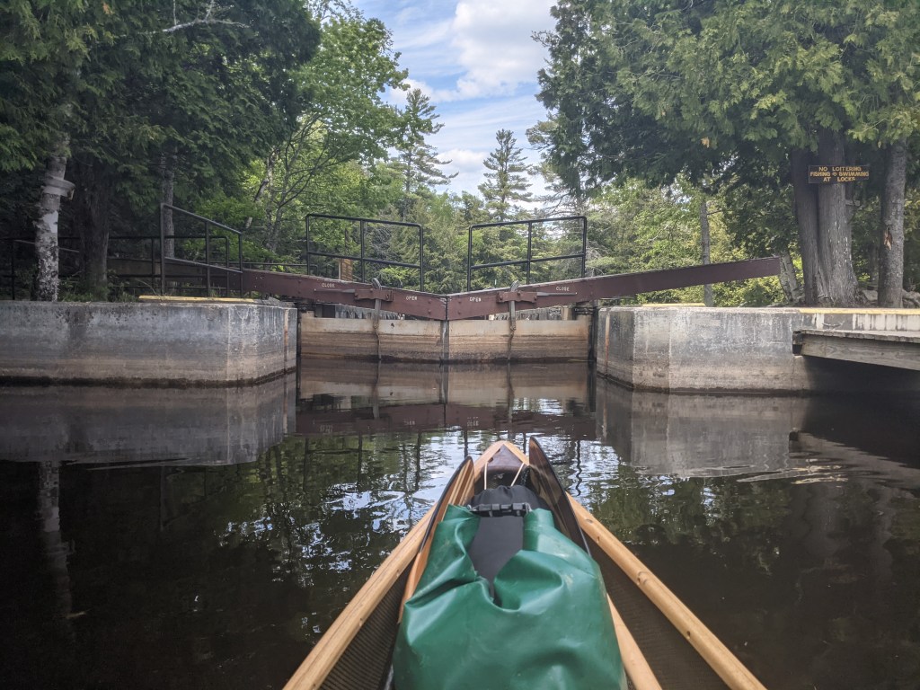
There was no attendant so I had to read the instructions to do it myself. The instructions are not incredibly clear (I must have missed the day of school where we learned about what wicket doors are). But I figured it out and helped the a boat going up stream get through too.
I made my way through Lower Saranac to the Lower Gates, this time with an operator, hydraulically controlled none the less. There were signs for a canoe carry to the right of the damn but no where had I read I needed to carry here. He let me through the lock, and as the water level was going down he came out to chat. I asked about the carry and he said if it’s busy they try to keep it to motor boats but he was bored and would let me through all day he said.
After the locks I was into Oseetah Lake, this and the portion above the Lower Locks, were flooded forest at one time. And dead wood sticks out of the water many places (above the locks there was some visually interesting roots and branches). The marker buoys are heavily present here to make sure boats don’t run a ground in these spots.
Oseetah was pretty with mountains around and neat camps on shore or on islands. I was a little unsure where to go as the map I have doesn’t have the detail or resolution to show the minutiae of the shore. I made it anyhow and trudged into Lake Flower.
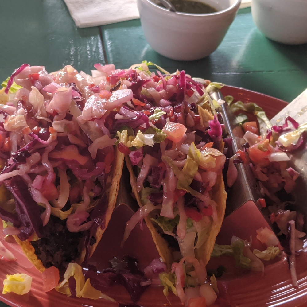
I was pretty tired at this point and it was after 6 so I figure the outfitter was out of the question at that hour. I made it to the end of the lake where the portage is, and called for a motel. I ended up at Gauthier’s and had to back track down the lake to get to them. I made like a baby duck in a Dawn Dish Soap commercial and showered caked on layers of sunscreen and bug dope off. And walked to Casa del Sol a neat Mexican restaurant right across the street practically. Delicious!
I’m staying here tonight and I don’t think I’m in a rush to get going in the morning. I feel a little under the weather nothing serious but just “off”. I’m hoping it’s allergies, not enough water, and inhaling bug spray and not a cold or something. We’ll rest up tonight though! Cheers!

Hey Josh ! no joke , those tacos look tasty as all get out !!! bet you will sleep good with those under your belt !!! weather looks real nice for the next several days 😎 … enjoy it to the max hon !!! oh yeah, Sarina’s enjoying your posts too !!!
Love ya ,
Auntie Stella
LikeLike