Eustis, ME to Spencer Stream
Late start to the canoeing year! It’s was a busy May and June, and to be honest with all the rain in the Northeast I haven’t been too motivated to get out there. My coworker and friend Ryan had shown interest in joining me on a leg of my canoeing adventures. I had convinced him that we should resume the northward leg where Kyle and I left off in September. That portion of the Penobscot should be a nice downstream section… the catch is we’d have to do the arduous Mud Pond Carry, but what better way for bonding than mutual suffering?
Once again we were going to use the pilot to help us with the logistics. The week before the trip I called the pilot, and he informed me that I had best contact the ranger stations in the area. The Moosehead area had experienced a lot of rain, and a big storm dumping three inches of rain the night before. Apparently many campsites were underwater and the river was up to the bottom of some bridges making them impassable from below. Long story short, we decided to make an audible and decided to go from base of Flaggstaff Lake in Eustis to Jackman, ME.
Our goal was to complete the journey in three days with a fourth contingency day. Starting in Eustis we would traverse the winding Flaggstaff Lake, a lake formed by the damming of the Dead River at Long Falls in 1950. The lake ends at Long Falls Dam where we would portage around and continue downstream on the Dead River to Grand Falls for another portage before turning upstream on Spencer Stream and its tributary Little Spencer Stream. The latter flows out of Spencer Pond, where after a five mile portage we could commence downstream on the Moose River flowing through Attean Pond, and thence to Wood Pond adjacent to Jackman.
Day 1
We started our drive a little later than intended after stopping for coffee and breakfast sandwiches. The day was beautiful and sunny after what seemed like a month of rain. We put in at Flagstaff Boat Launch around 9:30, the day already warm and humid with some horseflies and mosquitos looking for lunch. We held up a line of boat trailers eager to launch and take advantage of the summer day.
We took paddled along the northern shore of the lake. Bigelow Mountain was green and prominent despite the hazy air, and we made our slow horseshoe around the mountain. The Appalachian Trail follows the ridge of the moutain before descending past West Carry and East Carry Ponds finally crossing the Kennebec. This area is known as the Great Carrying Place between Flagstaff and the Kennebec. Benedict Arnold crossed the 12 mile stretch of land in October of 1775 to pass an unnavigable stretch of the Dead River. 1100 men attempted the journey from Cambridge to Quebec City. Only 600 made it to the city to be joined with men led by Richard Montegomery in the failed Battle of Quebec. The mountain is named after Major Timoth Bigelow, who climbed to the top of the mountain in October of that year to get a lay of the land.

We stopped for lunch on a sandy bit of shore, and saw a couple other paddlers along the way, despite the sparsely populated shorelines. Poor Ryan’s knees were already burned red despite a few applications of sunscreen. Lunch took longer than I wanted as the food was too hot to eat, being so warm it took awhile for it to cool down. After lathering with more sunscreen and bugspray we continued onward.
We had been lucky so far as the lake was largely still and calm. The guide books report people being held up for days waiting for winds to become more favorable on this large lake. As we neared the southeastern end of the lake the winds were against, and we worked hard to round the point of land to push north up the lake to Long Falls Dam. After rounding the point the wind was more or less pushing us in the direction we wanted. This last stretch took us little time and we saw the bern of gravel leading to the dam and its accompanying boom.
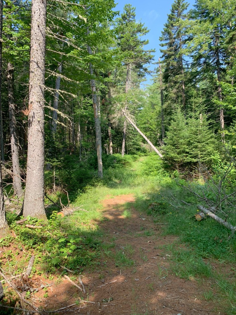
Katina’s book reports the portage start as “obvious”; as it turned out it wasn’t obvious to us. We saw a faded yellow sign high in a pine tree, and tied up the canoe to investigate. The description called for an open area and barrier rocks to be passed before accessing the dirt road. None of this was to be found, and we decided to get back in the boat and search further. We went along the shore as near as we dare to the boom and still no more signs. So we turned back to our first choice and unloaded for our mile long portage.
Despite being on decent dirt roads the portage was tough. The big yellow polyurethane Kineo canoe is an 85 pound monster, a far cry from my 25 pound Kevlar canoe I’m used to lugging around. A vile combination of sweat, sunscreen, and bug spray would run down our arms to our hands making gripping the plastic boat difficult and encouraging blisters. We passed rock barriers blocking an open area after awhile. I can’t imagine going that much farther to find the correct portage takeout, and my only explanation is the with the water so high the boom has been moved further up than in normal conditions.
Although a little disheartened knowing we had unintentionally extended our portage we knew that we were on the right track. We passed a spot to look over Long Falls and which followed a track along the river. This is the designated portage but we opted for the easier if longer option along the road. We crossed over a bridge and made it to tarmac and Big Eddy Campground, which looked like a glorified gravel pit next to guard rail, but was next to the river at least. We chatted with a couple there fishing for brookies, salmon, and rainbow trout.
It was approaching evening now, and we had made it to our goal. But I knew tomorrow would be a difficult day and the closer we got to the confluence with Spencer Stream the better. We agreed to go on a little further downstream which should be easy miles. The first half mile or so was speedy thanks to the rapids following Long Falls area, but slowed to a steadier pace further on. The iron rich tea colored river was quiet and we saw several eagles, one youngster trying his hand at hunting a duck or fish. A couple loons and one beaver also bore witness to our passage.
Despite starting later, we took advantage of the long day to make it to camp. Though I grew anxious as the sun was below the treeline now. We consulted the map and carefully followed the western shore to look for Philbrick campsite. Ryan spotted a little wooden sign obscured by brush which I would have missed. A slippery treacherous track up the steep bank brought us to the dead end of a dirt road. If it weren’t for the mosquitos it would have been nice campsite.

Day 2
After a long night of unrelenting humidity, I wondered why I bothered bringing my sleeping bag and if I could pull the sleeping mat off my sticky skin, Ryan and I made cold breakfast and began packing. The mosquitos made any chore outside the tent all but unbearable. But in due course we were back on the water.
We had what turned out to be about 2 miles downstream before another mile long portage around Grand Falls, and then beginning our 10 mile upstream journey to Spencer Pond. The morning was foggy and we had little conversation hoping to see a moose. No dice.
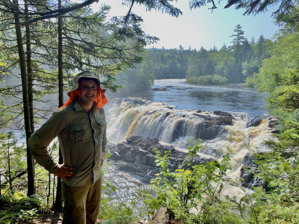
We made it to the dock of Maine Huts and Trails where the portage around the 40 foot Grand Falls began. I scouted ahead to see how far over spruce roots and grass before we reached the road. I told Ryan it would be better to carry the bags and canoe separate until we reached the road. So we loaded up with bags and started down the way. It was probably a tenth of a mile to what I thought was the road but turned out to be a wooden bridge. Instead we walked a half mile ending by crossing a footbridge to the dirt road (this being a generous term as it was closer to a 4-wheel track than road). As a result we walked the half mile back to the canoe and another half mile with the canoe to our bags.
Already sweating and tired, we took a water break and had some snacks before we started uphill for the next half mile of our portage. We decided to leave the boat empty, and come back for our gear. Some combination of heat, slipping hands, the 24 miles of paddling from the day before, and a damned heavy canoe made this portage rough. Swatting at mooseflies one handed didn’t help anything either. Ryan was ever the optimist wearing a smile despite the hardship and I tried to hide my concern for his sake, but I was absolutely dreading the five miles we had to portage on the next day. Would we be able to contact my aunt and tell her to postpone pick up to Sunday?
In any case, we eventually made it to the put in. After quickly catching our breathes, we hiked back along the trail following the river to get our gear and see the falls. Grand Falls was beautiful, and made the difficulties and heat all worth it. In June apparently a group of whitewater kayakers attempt the falls and film their endeavors. I’d like to return to watch sometime. Here is a link to “Huckfest 2022“.
We put in and after 30 yards or so downstream we turned up Spencer Stream. Almost immediately this became a challenge. The streams flow was strong and though it would appear deep enough to paddle over the rocks, the current would often prove too strong to paddle. We hopped out and began trudging up the slippery uneven riverbed. Ryan had a hard time staying upright, and I tried my best not to laugh, but I’d be lying if I said it wasn’t funny as he flailed around falling. But as it would turn out, Ryan would get the last laugh.
The weather had held up surprisingly well, but we knew thunderstorms and rain were coming in the afternoon. Soon to the north we could see slate colored cumulus clouds framed by the river’s corridor. Around noon we wedged ourselves into some rocks and made cold lunch. I looked at the GPS, we had only made about four miles, that meant we were going around one mile per hour. Not good. At that pace we’d arrive at camp around 8 PM in the rain.
We took a good hour at lunch trying to find strength for the journey ahead. Ate some point I recall Ryan asking me “what do you think?”, despite his smile he was also thinking this was not going well. Unfortunately, there’s no sites between Grand Falls and Spencer Pond. The woods are thick with spruce, birch, and undergrowth among the stony banks. Setting up a tent would be nearly impossible.
The current continued to be too strong to paddle in the deeper sections, and the water level was frequently above my knees making for difficult walking. We got to a section where I tried to power ahead lone in my frustration to cover ground. I came to an eddy close to hip deep. Ryan was probably 30 yards behind me catching up. I needed to cross to the other side of the river where it was shallower and easier to walk. Before doing that I climbed up a rock to catch my breath and look up stream.
Unfortunately I lost my footing and fell down. In doing so, the sharp edge of a rock ran up along my ankle. It hurt immediately and I was angry at the pain and the humiliation of falling. Grabbing the gunwales and ledge to pull myself up, scrambled back up the rock to look at my ankle. Despite the pain it appeared at first to just be several scrapes. My moment’s reprieve stolen from me as I noticed a deeper cut covered by a flap of skin, and soon blood began to flow.
I waited for Ryan to approach and assess the situation. Now, as I don’t work in the medical profession, this was more blood than I’m used to seeing. And though I didn’t think I would bleed to death, I thought maybe stitches would be needed, and was worried about possible infections. Ryan took a look and agreed going onward was not wise nor worthwhile. Ryan wrapped my cut as I leaned onto the rock trying to keep my foot out of water. We hopped in the boat and made a mad scramble downstream.
Thunder threatening behind us and some rain drops warning of the coming storm, we paddled in forty minutes what took us probably over two hours to ascend. We took out at the Dead River Put In and set up camp before the rains really came. We washed out my wound with clean water and applied new bandages, Ryan playing doctor After some debate we decided waiting until morning for a ride would be wisest, as it was getting dark and stormy, and navigating uncertain logging roads to find us could be dangerous.
I won’t belabor the story, but suspicions confirmed when finding us in the morning turned out to be easier said than done with limited communication abilities. An older gentleman was fishing in the morning (the first person we had seen in over 24 hours as Ryan pointed out). I asked him if the roads were passable as I was worried about fallen limbs or other obstructions. “Well I rolled in here, didn’t I?” O you’ve got to love that Maine wit. Beyond that he seemed mostly only interesting in telling us about fish he’s caught. He showed us pictures of brook trout and salmon, I asked him if he caught them there at Grand Falls. “You think, I’d tell you?” I guess there’s some old school guys still out there. Eventually, Ryan and I decided to hike out to make sure my aunt didn’t miss the turn to our location, which we did and eventually got our ride. I said I wouldn’t belabor the story but here I am doing it anyway.

Wrap Up
Well that’s the long and short of this trip. Late start to my season and a week late in writing the blog, but better late than never as they say. In all we did 29 miles or so, 24 the first day and only 5 the second day. Happy for the one day of good weather on day 1, and though I’m disappointed my miles are going to be low this year (and I’m dreading having to reattempt Spencer Stream) and glad I got out there at all. Luckily neither Ryan nor I was hurt seriously.
Not sure what is next. I’m hoping for some better weather in August and lower water levels, but it might be September before you hear from me again!

You must be logged in to post a comment.